Download Technical Notes on Hydrology and more Summaries Hydrology in PDF only on Docsity!
JAOCHICO, JOSHUA B. MODULE 1, CW # 2
2018150755, CE- 3
CE141-2, E
I. PRECIPITATION AND INTERCEPTION
PRECIPITATION
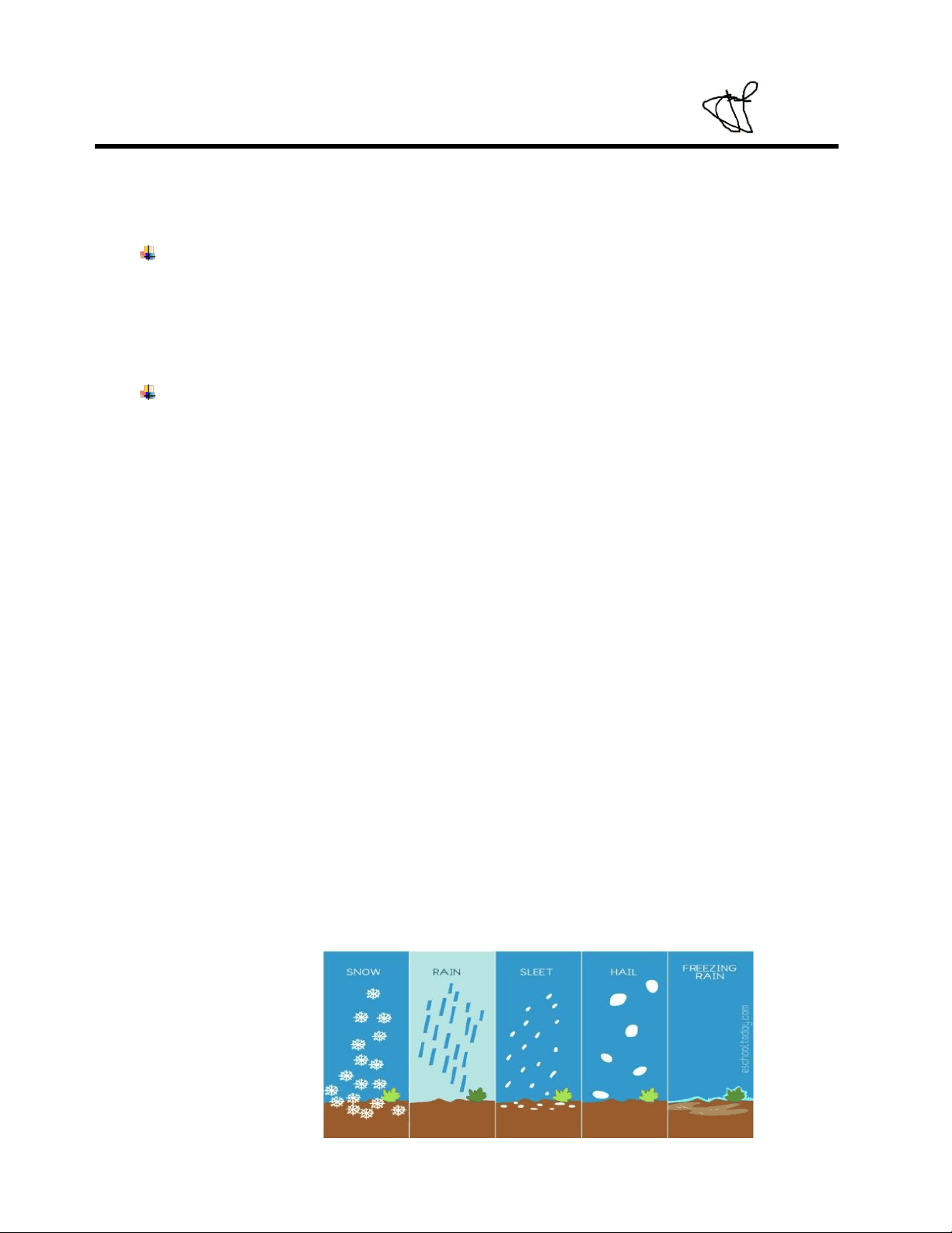
o is defined as the act of transferring water from the atmosphere to the surface of the Earth via the release of water by clouds in the form of rain, snow, sleet, hail, or freezing rain. o a highly variable phenomenon that does not occur in the same amount over a large area or even inside a single city. CLOUD FORMATION ➢ CONDENSATION o The formation of clouds is followed by condensation, which is the transformation of water vapor into liquid. o Water evaporation is the process through which liquid water transforms into vapor, which is the inverse of evaporation. o A parcel of rising air expands and cools until some water vapor molecules mix, when a thunderstorm occurs. ➢ LATENT HEAT o Evaporation releases Latent Heat, which is the heat absorbed during evaporation, which is released in this process. ➢ DEW POINT o The temperature at which a specific air parcel becomes saturated and begins to condense as a result of its temperature; the temperature at which the air must be cooled (at constant pressure) to achieve a relative humidity (RH) of 100 percent; the temperature at which the air can no longer hold any more water in the gaseous state at this point; the amount of moisture in the air increases as the dew point rises. o In addition to expanding and coming into touch with an extraordinary object, such as a cold continent or an ice-covered coast, air cools as it moves through space. o The additional water vapor condenses on surfaces and objects in the atmosphere and on condensation nuclei (small particles, aerosols, or ice particles), resulting in the formation of droplets when the temperature lowers even more. Figure1. Precipitation
A. CLASSIFICATION OF PRECIPITATION
PRECIPITATION: To categorize precipitation, the factors that caused the lifting of moist air masses are considered.
1. PRECIPITATION IN OROGRAPHIC FORM OROGRAPHIC LIFT o When topographic barriers such as mountains are present, moist air masses may be lifted to higher elevations, resulting in cooling condensation and precipitation. In the meteorological world, this kind of precipitation is referred to as orographic precipitation. Precipitation is heavier on windward slopes than it is on leeward slopes, and the difference is significant. CONVERGENT LIFT o The term "convergent lift" refers to the phenomenon that happens when air streams move toward one another, as is typical on islands or peninsulas. As a consequence of convergence-induced lift, clouds and precipitation may be seen in the vicinity of low pressure centers. Generally speaking, the higher the convergence, the stronger the vertical motion, and the greater the probability of clouds and precipitation in the forecast. CONVECTION LIFT o A parcel that is warmer and less dense than the surrounding air causes convection lift, which occurs when this happens. When the sun warms the ground, convection forces the warmed air near the surface to rise, causing the temperature of the Earth to increase as well. The rising thermals have the appearance of hot water bubbles rising from the bottom of a boiling pot of water. As long as the air is steady, warm air bubbles will create dispersed fair weather cumulus clouds, but nothing more will happen. If the air is unstable, the lifting caused by convection will cause clouds to quickly develop into deep cumulonimbus clouds, which are thunderstorms in their most severe form. Furthermore, the higher the surface temperature, the greater the likelihood of convection occurring. 2. PRECIPITATION IN THE CONVECTIVE MODE o Precipitation produced by the upward migration of warmer air from the surrounding air, which has a high degree of unpredictability and is difficult to forecast o Because of its lower density, air near the heated ground warms up and rises in the atmosphere. o The contrast between a scorching naked field and a cool wooded area may explain the impact, according to some theories. Streets and rooftops in the city are becoming warmer. o The cooler air replaces the warmer air in the convective cell that surrounds the cooler air. o In the presence of precipitation, warmer air continually rises and cools, creating a cyclical pattern. o The aerial extent is restricted to a circle with a diameter (circumference) of about 10 kilometers.
TIPPING BUCKET GAUGE
o A tipping bucket rain gauge is one of the most often seen instruments in weather station applications. o This set of rain gauges includes a rain-collecting funnel, two precisely calibrated "buckets" placed on a pivot point, and an electrical switch, among other features. WEIGHING-TYPE GAUGE o The weighing bucket kind of self-recording rain gauge is the most often seen type. o In addition, it is composed of a receiver bucket that is held by a spring or lever balance, or by some other weighing mechanism. o As the weight of the bucket rises, the movement of the bucket is communicated to a pen, which draws a record or makes a mark on a clock-driven chart FLAT-RECORDING GAGE o As the name implies, a float sitting on the water's surface acts as a rain gauge, and its location determines the amount of rainfall collected. o Through the use of a linkage, this instrument is often employed as a rain gauge by connecting the float to a pen that records the amount of rain on a clock-driven chart. C. PROCESSING OF RAINFALL DATA Raw precipitation data may include gaps and inconsistencies; thus, it is essential to conduct preliminary checks, inspection, and validation on the data before putting it in a database or utilizing it for further research. It is important to note that while processing rainfall data, two main objectives are in mind: first is to identify and remove data mistakes; and second is to arrange the data in a manner that will be helpful for future studies. The following information may be included in the rainfall data: o Entries made on the incorrect day o Entries that were moved o Entries produced as accumulations o Missed entries o Inaccurate rainfall measurements on days with less rainfall
THE ARITHMETIC AVERAGE METHOD
In order to calculate the average precipitation depth across a catchment region, the most basic approach is to take an arithmetic average of the recorded precipitation depths at gauges located inside the catchment area during the time period in question. The average amount of precipitation is represented as: The average catchment precipitation derived from data from n stations is denoted by the letter P, while the precipitation at station i is represented by Pi. THIESSEN POLYGON METHOD A technique for assessing the geographic relevance of point rainfall data. Bisectors are constructed along the lines that link each measuring station to the ones that surround it, creating perpendicular bisectors. When these bisectors are joined together, they create a sequence of polygons, each of which contains a station. In order to compute the mean areal rainfall, the precipitation value recorded at a station is allocated to the whole region encompassed by the enclosing polygon. Mean areal rainfall: THE ISOHYETAL METHOD This method is used to estimate the mean precipitation across a large region by drawing lines of equal precipitation throughout the area.Topographic and other data are used in conjunction with the technique in order to produce accurate estimations. As with contour lines on a topographic map, isohyets are equal precipitation contours that are symmetrical in nature. Mean areal rainfall:
WIND SPEED
o Evaporation rises in proportion to the increase in wind speed. The rate of evaporation and the speed of the wind are related to one another ATMOSPHERIC PRESSURE o A reduction in air pressure (as occurs in high altitude regions) increases the rate of evaporation when all other variables are held constant; this is especially true when all other factors are held constant. VAPOR PRESSURE o The difference between saturation vapor pressure (SVP) at water temperature (ew) and actual vapor pressure in the air (ea) determines the rate of evaporation. o Evaporation happens when ew equals ea. Condensation, on the other hand, occurs when ew > ea. SOLUTION SALTS o When a solute is dissolved in water, the vapor pressure of the solution is lower than the vapor pressure of pure water, resulting in a slower rate of evaporation than when the solute is evaporated alone. B. MEASUREMENT OF EVAPORATION o The rate of evaporation is the volume of liquid water evaporated from a unit area per unit of time. o It may be described as the depth of liquid water evaporated per unit of time from the whole area. o A day is often used as the unit of time. o The quantity of evaporation should be recorded in millimeters. o In general, a measurement precision of 0.1 to 0.01 mm will apply, depending on the kind of equipment. C. TRANSPIRATION AND EVAPOTRANSPIRATION TRANSPIRATION o Water is changed from a liquid to a gas when it travels through the plant's stomata, which are tiny holes on the undersides of vascular plant leaves, in the process known as transpiration. EVAPOTRANSPIRATION o Evapotranspiration is the total of evaporation from the ground surface and transpiration from plants, and it is a measure of water loss from the atmosphere. D. METHODS OF ESTIMATION DIRECT METHOD o Water Budget Technique o Lysimeter Indirect Method o Mass Transfer Method o Energy Budget Method o Hargreaves Method
III. INFILTRATION AND SOIL MOISTURE
A. INFILTRATION PROCESS
As a part of the overall unsaturated allocation process, the infiltration process results in soil moisture availability for use by vegetation transpiration, exfiltration (or evaporation) processes, chemical transport, and groundwater recharge. Infiltration is a component of the unsaturated allocation process. To this end, soil moisture is responsible for controlling the fragmentation of future precipitation into infiltration and runoff, and for regulating the partitioning of available energy between sensible and latent heat flux. B. SOIL WATER PROPERTIES AND ESTIMATION SOIL WATER PROPERTIES o The coefficients of soil moisture tension, conductivity, and water holding capacity are computed using the soil texture as a starting point and with adjustments for gravel content, compaction, salt, and organic matter. If you choose to use the numbers supplied, bear in mind that they are estimates and may not accurately reflect the true values in a particular scenario. Upper and lower limitations on the input values have been established in order to guarantee the correctness of the estimates. THE METHODS OF ESTIMATION FELL METHOD o By touching the soil, the feel method may be used to estimate the amount of soil water present. Due to the ease with which this method may be used, many farmers use it to plan irrigation. This technique, on the other hand, is fundamentally subjective; the findings are decided by the person who is conducting the estimate. o The feel technique is not advised and should only be used as a last option in the majority of cases. GRAVIMETRIC METHOD o To assess soil moisture using the gravimetric method, a soil sample is taken from the appropriate soil depth and weighed before being dried in an oven (at 220°F for 24 hours) and reweighed to determine how much water was lost during the drying process. This technique is simple to use and has shown to be reliable. o This technique is particularly helpful for calibrating other soil-water monitoring instruments.